News
Database on municipal development in the Alps
Jul 17, 2008
/
alpMedia
How do my town and region perform in terms of employment, demographics, structural diversity, agricultural and near-natural land use, structural change in agriculture, and landscape fragmentation in the Alpine space?

Image caption:
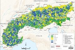
Einzelne Daten wurden im Rahmen von DIAMONT zu thematischen Karten aufbereitet. © DIAMONT 2008
Answering these and many other questions was the goal of DIAMONT, a recently completed INTERREG IIIB project, in which a spatial development indicator database was created as an objective tool for comparative working throughout the Alps. The database, which is freely accessible to the general public in the Internet, provides data on a total of 81 indicators relating to social, ecological and economic aspects of life in the Alps. The data can be selected for individual municipalities and for higher-level spatial units. The website also has maps as a more graphic style of presentation for twelve of the indicators such as available settlement area, forest area and private service sector jobs. In addition to the statistical data, the English-language website also offers access to over a hundred spatial development instruments for land resource management in the Alps and numerous links to examples of best practice for selected instruments. Database: www.diamont-database.eu (en)

